本日2月27日を227と3ケタの数で表すと、227は素数です。西暦を含めた20180227は53、349、1091という3つの素数で割り切れるので、素数ではありません。
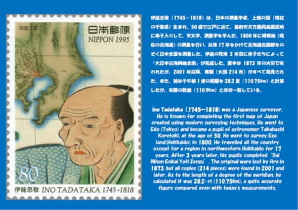
今回は、立志館3階、数学4教室入口に掲示している「伊能忠敬」のパネルと説明文をご紹介します。
伊能忠敬は55才から71才まで10回の測量を行い、大図214枚、中図8枚、小図3枚の「大日本沿海與地全図」を完成させました。大図の縮尺は36000分の1です。彼が測量できなかった北海道北西部は、樺太を探検し間宮海峡を発見した間宮林蔵が測量し、地図が作られました。
伊能忠敬の功績を記念して、彼が家業を営んだ千葉県香取市に伊能忠敬記念館があります。彼の作った地図を直接見ることができます。ぜひ一度ご覧になってください。
(数学科 園田)
Ino Tadataka (1745-1818) was a Japanese surveyor. He is known for completing the first map of Japan created using modern surveying techniques. He went to Edo (Tokyo) and became a pupil of astronomer Takahashi Koretoki, at the age of 50. He went to survey Ezo land(Hokkaido) in 1800. He travelled all the country except for a region in northwestern Hokkaido for 17 years. After 3 years later, his pupils completed“Dai Nihon Enkai Yoti Zenzu”. The original ware lost by fire in 1873, but all copies (214 pieces) were found in 2001 and later. As to the length of a degree of the meridian, he calculated it was 28.2-ri (110.75km), a quite accurate figure compared even with today’s measurements.

“The name of math classroom 4 is ‘Ino Tadataka’.”
We will introduce the panel of “Ino Tadataka” and a document to explain the panel this time.
Ino Tadataka surveyed all the country 10 times from when he was 55 to 71 years old, and he made “Dai Nihon Enkai Yoti Zenzu” with “Dai-zu” of 214 pieces, “Chu-zu” of 8 pieces and “Sho-zu” of 3 pieces. “Dai-zu” are maps drawn on a scale of 1 to 36000. Mamiya Rinzo who explored Karafuto (Sakhalin) and discovered the Mamiya Strait (the Tatar Strait) surveyed northwestern Hokkaido where Ino Tadataka could not survey.
There is an Ino Tadataka museum at Katori-city, Chiba-prefecture. There we can directly see the maps he made. I recommend that you go there.
by Tsuyoshi Sonoda (Math Dept.)


