 本校ではかなり多くの生徒のみなさんが、地下鉄烏丸線を利用しています。そしてそのほとんどの人が「北山」駅から「国際会館」駅まで地下鉄の車両の中にいると思われます。その時は、友だちと話に夢中になっていたり、本の世界に入り込んでいたり、その日の英単語のテストの勉強をしている人もいるでしょう。実はそんな時、みなさんは地質学的にはとんでもない場所を通過しているのです。
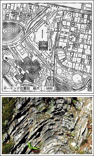
下の横長の図は、地下鉄工事の際に作成された「地質断面図」です。「松ヶ崎」駅から「国際会館」駅の間には高く聳える山が描かれていますが、ここが宝ヶ池南側の山域(五山送り火の「妙法」の山)です。地下鉄はこの山を形成している岩盤を貫通して走っているのです。山の断面図には小さい文字で「ch,sh,sst」と読み取れます。それぞれ「チャ-ト、頁岩、砂岩」の事です。このチャ-ト層の地表での様子が右の写真です。この石が今から2億年ほど前に赤道直下で堆積した放散虫というプランクトンでできているのです。…ということは、みなさんは登校時、「松ヶ崎」駅を出発後、赤道で堆積した2億年前の深海底を旅していることになるのです。
(2つの図は京都市交通局高速鉄道本部提供)

A large number of our students take the Karasuma Subway Line to and from school each day. While on the subway, they often chat with their friends, read books or study for their tests. They probably don’t realise that, as they go between Kitayama Station and Kokusaikaikan Station, they are passing through a geological wonder.
In the bottom picture you can see a plan for how the subway lines pass between Matsugasaki Station and Kokusakaikan Station through a small mountain. The symbols in the picture “ch, sh, sst” indicate the different types of rock that run through the mountain. Of these, Chert (“ch”) is thought to have been formed more than 200 million years ago under the oceans. These means that the students on the subway would have been traveling under the ocean 200 million years ago.


