 この夏は猛暑と集中的な大雨が特徴的でした。
8月23日深夜から翌朝にかけての台風20号の暴風には、気象現象のもつエネルギ-を見せつけられました。
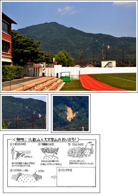
さて、8月のある時、本校から比叡山方向を眺めた時、比叡山南方の山の中腹斜面が削られている箇所が目につきました。右はその箇所を順に拡大した写真ですが、山肌が「白っぽい」ことが確認できます。一番下の図は3年生理科Ⅱの授業で紹介している図ですが、4の図にあるように比叡山と大文字山は「比叡花崗岩」という岩石の分布域です。今から約7800万年前にマグマが固結してできた花崗岩は風雨にさらされ風化すると白い砂(まさ土)になります。これが「白川砂」です。
京都盆地の東側を流れる白川の河床が白いのはこの砂が原因です。
1972年9月16日、台風20号の豪雨により、修学院音羽川上流で土石流が発生し、270世帯が被害を受けました。この場所も花崗岩分布域でした。花崗岩分布域は風化が進みやすいので豪雨時は細心の注意が必要です。
みなさんも登下校中の東山のようすを観察して、東山を形成している地質の特徴と災害について考える機会にしてみてください。
This summer we experienced extreme heatwaves and heavy rainfalls. On August 23rd a typhoon passed through with a lot of power.
One day in August, while looking up from the school field, we could notice some landslides on Mt. Hiei. You can see these in the photos on the right. In our 3rd Year science classes the students learn about how Mt. Hiei and Mt. Daimonji were formed 78 million years ago when magma became granite. Over many years of wind and rain this eroded and became a white sand. Because it is a soft sand, it is easily affected by heavy rain and prone to landslides, such as in 1972 when 270 homes were damaged.
When we look up at the mountains in the east, we are always reminded of how the geology can cause disasters.


